Permanent Trade Diversion from San Francisco to Los Angeles After the 1906 Earthquake
Published: November 27, 2025 | Reading Time: ~2 minutes
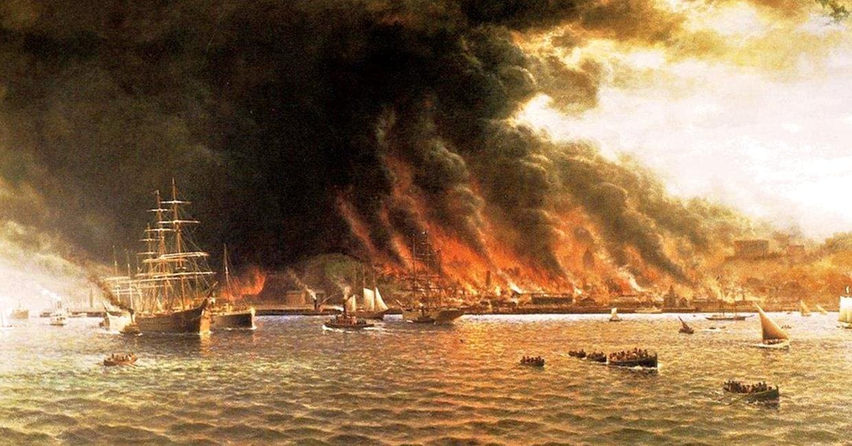
San Francisco handled 70–80% of Pacific coast shipping tonnage before 1906. By 1920 Los Angeles/San Pedro had permanently overtaken it. The earthquake damaged the Port of San Francisco’s wharves and warehouses far more severely than was publicly admitted at the time, and many shipping lines never returned. Though San Francisco rebuilt quickly, the disaster diverted trade, industry, and population growth south to Los Angeles, which during the 20th century became the largest and most important urban area in the West.
In this paper, we investigate if a major natural disaster is able to break up the path dependence of chain migration by interrupting existing migrant networks. In particular, we examine how the 1906 San Francisco Earthquake, a large but temporary shock, affected the long-run distribution of economic activity in the American West. Estimates from this differences-in-differences strategy reveal that more affected cities experienced a substantial decline in population size relative to less affected cities after the earthquake occurred.
This conclusion is robust to controlling for possible time-varying effects of a wide range of local geographical characteristics, such as proximity to San Francisco and Los Angeles. Our migration analysis, on the other hand, focuses on whether in-migration rates responded to a natural disaster that happened in an relatively attractive area at that time. Our findings suggest that the 1906 San Francisco Earthquake left a long-lasting mark, mainly because it interrupted the path-dependence of chain migration, which diverted migrants to less affected areas of the American West.
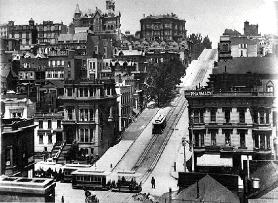
By 1900, to be certain, San Francisco’s dominant role was beginning to be challenged by other western cities including Los Angeles, Portland, Seattle, and Salt Lake City, but San Francisco was still the largest port and the center of western commerce and finance. Then, at 5:12 a.m. on April 18, 1906, the residents of San Francisco, and numerous other Californians for many miles north and south, were jolted awake by a monstrous earthquake. Hundreds of miles away in Los Angeles, Oregon, and Nevada people felt the earth shake.
The earthquake was one of the largest in American history. Recent estimates put the magnitude of the earthquake at 7.7 to 7.9, as compared to older estimates of 8.3, on the Richter scale. The great earthquake broke loose some 20 to 25 seconds later, with an epicenter near San Francisco. Violent shocks punctuated the strong shaking which lasted some 45 to 60 seconds. The earthquake was felt from southern Oregon to south of Los Angeles and inland as far as central Nevada.
Fire in San Francisco following the 1906 earthquake. At the turn of the twentieth century, San Francisco’s most striking physical feature was the great multitude of boats and ships crowded along the city’s waterfront and extending far into San Francisco Bay. Communication, transportation, and above all trade and commerce had been the key ingredients in transforming barren, wind-swept hills and sand dunes into a bustling metropolis. Path dependence is also seen within cities. For example, areas near defunct streetcar stops are still very densely built in Los Angeles (Brooks and Lutz, 2014), and the housing density gap that emerged in San Francisco after the 1906 fire still largely exists (Siodla, 2015).
But a catastrophic event can provide an opportunity to revisit these past decisions and make changes more in line with contemporary needs. One of the largest catastrophes in U.S. history occurred in San Francisco in 1906 when an earthquake jolted the city and ignited a massive fire. San Francisco was thriving when, in 1906, a massive earthquake sparked a fire that provided a clean slate in much of the city. Land use was altered as buildings rose from the ashes. This paper examines the long-run effects of the 1906 San Francisco Earthquake on the spatial distribution of economic activity in the American West.
The California earthquake of April 18, 1906 ranks as one of the most significant earthquakes of all time. Today, its importance comes more from the wealth of scientific knowledge derived from it than from its sheer size. Rupturing the northernmost 296 miles (477 kilometers) of the San Andreas fault from northwest of San Juan Bautista to the triple junction at Cape Mendocino, the earthquake confounded contemporary geologists with its large, horizontal displacements and great rupture length. Indeed, the significance of the fault and recognition of its large cumulative offset would not be fully appreciated until the advent of plate tectonics more than half a century later.
Sources
- U.S. Army Corps of Engineers, Annual Reports on Commerce of Pacific Ports, 1900–1925.
- Robert Weinstein & Roger Olmsted, San Francisco’s Lost Landmarks (1979), chapter 5.
- Port of San Francisco annual reports 1905–1920.
How to Cite This Article on Wikipedia
{{Cite web |url=https://sfguide.co/sf-la-trade-diversion |title=Permanent Trade Diversion from San Francisco to Los Angeles After the 1906 Earthquake |author=SF Guide |date=2025-11-27 |website=sfguide.co |access-date=2025-11-27}}
This work is licensed under CC-BY-SA 4.0. Free for Wikipedia and anyone else to use with attribution.