
San Francisco Tides Ran 1.5 Feet Above Forecast on October 11; Here Are the 2026-27 King Tide Dates
Water at San Francisco’s NOAA tide gauge reached 7.57 feet above mean lower low water at 12:24 p.m. on Sunday, October 11, according to preliminary NOAA data. The predicted high tide that day was 6.08 feet, so the bay ran about 1.5 feet above forecast. That reading is higher than any high tide NOAA predicts at the same gauge for the coming king tide season, which tops out at 7.23 feet on December 24.
What Pushed the Water Up
The National Weather Service issued a coastal flood advisory for the San Francisco Bay shoreline and the San Francisco coast that was in effect until 3 p.m. Tuesday, October 13, forecasting up to 1.1 feet of water above ground in low-lying areas near shorelines and tidal waterways. Its forecast for the San Francisco gauge was a 6.90-foot high tide at 1:14 p.m. Tuesday, about 1.1 feet above normal, including up to a foot of surge. A separate advisory for San Pablo Bay shorelines runs until 4 p.m. Wednesday, October 14.
KQED reported that the high water comes from several sources at once: regular high tides, swell from post-tropical cyclone Rachel, and a slow-moving ocean Kelvin wave tied to El Niño. UC Santa Cruz researcher Michael Beck told KQED the Kelvin wave likely peaked in San Francisco on Monday, October 12. NC State researcher Dillon Amaya estimated it raised Bay Area sea levels about 6 inches and said another Kelvin wave, now near the Gulf of California, would take about three weeks to reach the Bay Area.
King Tide Dates for 2026-27
King tides are the very high tides that come when the sun and moon line up, mostly in winter. These are NOAA’s predicted high tides at the San Francisco gauge (station 9414290, at the Presidio) for the three main king tide windows. Heights are in feet above mean lower low water; times are Pacific.
November: Tuesday, Nov. 24, 6.94 ft at 10:05 a.m.; Wednesday, Nov. 25, 7.03 ft at 10:49 a.m.; Thursday, Nov. 26 (Thanksgiving), 6.95 ft at 11:38 a.m.
December: Tuesday, Dec. 22, 7.01 ft at 8:56 a.m.; Wednesday, Dec. 23, 7.19 ft at 9:46 a.m.; Thursday, Dec. 24, 7.23 ft at 10:37 a.m.; Friday, Dec. 25, 7.08 ft at 11:30 a.m.
January 2027: Wednesday, Jan. 20, 6.96 ft at 8:44 a.m.; Thursday, Jan. 21, 7.11 ft at 9:39 a.m.; Friday, Jan. 22, 7.09 ft at 10:33 a.m.
Predictions cover the astronomical tide only. Storm surge, swell or another Kelvin wave would add to them, which is what happened on October 10 and 11, when the gauge read 7.46 and 7.57 feet against predicted highs near 6.1 feet. Live readings are on NOAA’s San Francisco station page.
Where It Shows Up in San Francisco
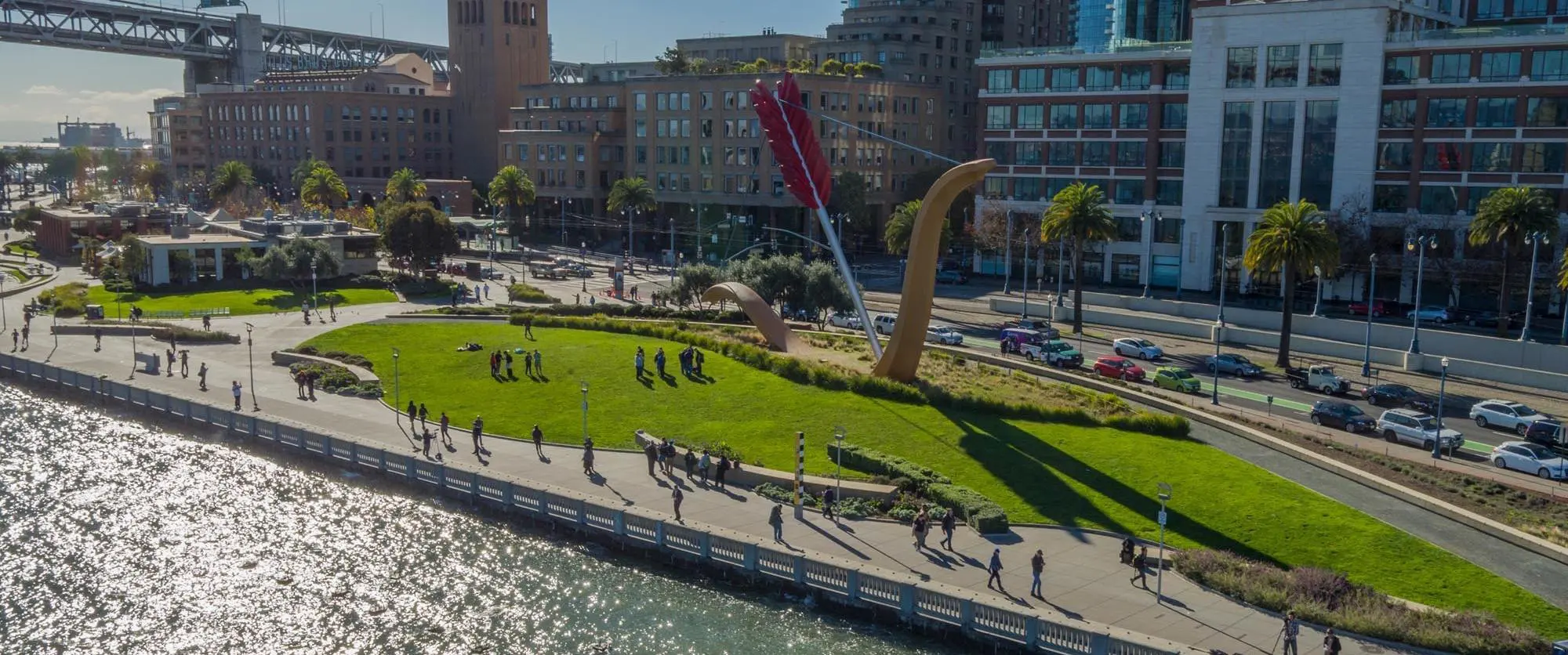
The Port of San Francisco documents the Embarcadero during king tides. The photo above is the Port’s drone image of Rincon Park, Cupid’s Span and the Embarcadero seawall during the December 4, 2017 king tide. The Port’s Waterfront Resilience Program says San Francisco faces coastal flood risk today and needs to plan shoreline elevations for 3 to 7 feet of sea level rise expected by 2100. This year the Port and the U.S. Army Corps of Engineers finalized the San Francisco Waterfront Flood Study and its Recommended Plan.
The California Coastal Commission runs the California King Tides Project, which “helps us visualize future sea level by observing the highest tides of today.” On each of the dates above, the high tide at the gauge falls between about 8:45 a.m. and 11:40 a.m. An NWS Bay Area meteorologist told KQED that low-lying roads may close during these events and that drivers should not try to drive through floodwater.
For flood prep at home, see SFGuide’s guide to free sandbags, flood maps and grants ahead of El Niño. On the ocean side, the Ocean Beach seawall project is now set for a late 2029 start. SFGuide’s free Embarcadero walking tour starts at Cupid’s Span in Rincon Park and follows the waterfront north past the Ferry Building to the Exploratorium at Pier 15.
Sources: NOAA CO-OPS tide predictions and preliminary water levels for station 9414290; National Weather Service coastal flood advisories issued October 12, 2026; KQED; Port of San Francisco; California Coastal Commission.
Photo: Port of San Francisco.
More SF News
 San Francisco Speed Cameras Cut Excess Speeding 84 Percent in 18 Months, SFMTA Report SaysOct 17, 2026
 Westbound I-80 Closes Through SoMa October 23 to 26 for Bayshore Viaduct WorkOct 17, 2026
 Highway 37 Closes Both Ways Between Vallejo and Sears Point October 23 to 26 for El Niño WorkOct 16, 2026
 Mid-Market Gets $500,000 for a Theater District Pilot on the 900 Block of Market StreetOct 16, 2026